2019 UK Flood Map Update

We’re pleased to announce the release of the 2019 UK Flood Map update. Our market-leading UK map covers river (fluvial), surface water (pluvial) and coastal flood across Great Britain and Northern Ireland at 5m resolution.

We regularly update our mapping to make use of the best available input data, including elevation data, rainfall and river gauge data, sea-level data and flood defence data.

The defended and undefended coastal flood maps have been updated for the north east, south east and south west coast of England. Several key cities in England and Wales have had river and surface water updates, with flood defence data updates in Scotland, Wales, England and Northern Ireland.

Through high-resolution mapping of flood, re/insurers can perform an indicative property-level flood assessment for improved risk selection, underwriting, pricing and portfolio management.

The map also separately identifies the three flood types, providing a more comprehensive insight into which flood type may be the driver of losses and what the potential claims costs may be.

The mapping is accompanied by a range of associated data, including simple flood risk scores and colour-coded flood ratings at property level. The latest UK Pricing Data release, which incorporates the updates from the 2019 UK Flood Map and provides a technical price for flood at each location, will be available in January 2020. We also offer a UK Flood Model for quantifying flood risk across a UK portfolio.

The mapping can also be used alongside our range of climate change data to understand potential changes in flood risk across the UK.

For more information on any of our UK data, please get in touch. We also have 5m flood maps available for the Republic of Ireland and Continental Europe, as well as 30m flood mapping globally.

News &
Insights

News Hurricane Milton approaches Florida

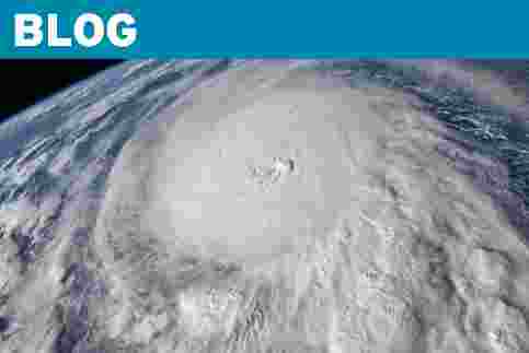
Dr John Ashcroft, shares his expert insight into how Hurricane Milton has developed and explains what sets it apart from Hurricane Helene.

Learn more
News JBA Risk Management joins B Corp™ movement

We are proud to announce that we have received B Corporation™ certification and have joined 9000+ like-minded organisations worldwide.

Continue reading
Blog A picture of future flood risk in Europe

Climate change is projected to increase the frequency and intensity of flooding but this can vary greatly on a regional and local scale. Our latest blog explores the significant variation and projected changes in inland flood hazard across some highly populated areas of Europe.

Continue reading
Blog The Ongoing Journey of JBA Flood Maps

JBA global flood maps underpin many aspects of our flood risk intelligence. In this blog we highlight the importance of the continuous improvement and ongoing work to review and update flood maps for all parts of the world to achieve the most-informed results.

Continue reading